STRING: thermistor string to measure ground temperature - Petuniabukta Contact Full Name Krzysztof Senderak email krzysztof.senderak@uwr.edu.pl Institution University of Wrocław Info Observation Facility Landing Page https://crios.pl/ Observation Facility Type land platform (fixed) Observation Facility Status Operational Core data Yes Part of SIOS Project CRIOS Observation Facility ID RiS ID(s) 12089 Geospatial location Coordinates POINT (16.456436 78.685726) Height above mean sea level (m) 5.00 Environment Site Information The hole in the vicinity of the UAM station in Petuniabukta was delineated at a distance of about 50 m from the shoreline, in the zone between the Polish and Czech stations. The drilling was carried out on 22-23.07.2023. The bedrock is built up by siltstone and sandstone. At the drilling site, they are covered by thick-bedded beach sediments. During the drilling, a depth of 7 meters below sea level was reached, and with no further drilling progress, a decision was made to install a string to the depth obtained. CRIOS – Cryosphere Integrated Observation Network on Svalbard Project financed from the EEA Financial Mechanism 2014-2021 operated by the National Science Centre in Poland Agreement no. UMO-2022/43/7/ST10/00001 to a predefined project no. 2022/43/7/ST10/00001 Project period: 08.09.2022 - 30.04.2024 (2029) Additional contact persons: Grzegorz Rachlewicz (grzegorz.rachlewicz@amu.edu.pl), Dariusz Ignatiuk (dariusz.ignatiuk@us.edu.pl) * height above mean sea level to check Observed Variable(s) Observed Variable CRYOSPHERE>FROZEN GROUND>PERMAFROST>PERMAFROST TEMPERATURE Start Date 2023-07-23T12:00:00Z Instrument model and serial number Thermistor string was manufactured by Geoprecision GmbH of Germany. Instrument routine maintenance Service of the thermistor string is planned at least once a year at the end of summer season. The battery in the logger should be replaced once every 5 years. Sampling procedures Thermistor string has the sensors at the following depths: 0.0, 0.05, 0.1, 0.2, 0.5, 1.0, 1.5, 2.0, 2.5, 3.0, 3.5, 4.0, 4.4, 5.0, 5.4, 6.0, 6.4, 7.0 m. Sampling every 1 hour and saving to internal memory. Read more about STRING: thermistor string to measure ground temperature - Petuniabukta
STRING: thermistor string to measure ground temperature - Calypsobyen Contact Full Name Krzysztof Senderak email krzysztof.senderak@uwr.edu.pl Institution University of Wrocław Info Observation Facility Landing Page https://crios.pl/ Observation Facility Type land platform (fixed) Observation Facility Status Operational Core data Yes Part of SIOS Project CRIOS Observation Facility ID RiS ID(s) 12089 Geospatial location Coordinates POINT (14.50072 77.56511) Height above mean sea level (m) 2.83 Environment Site Information On the coastal section selected for drilling at Calypsobyen, the bedrock contains siltstone and sandstone forming relict abrasion platforms, which are currently covered by loose sand and gravel beach sediments. The borehole was located near the mouth of the Scott River (right bank), at a distance of about 75 m from the shoreline and 900 m from the station. After stopping the drilling progress again at 5 m below sea level, a decision was made to install a string in the third hole. CRIOS – Cryosphere Integrated Observation Network on Svalbard Project financed from the EEA Financial Mechanism 2014-2021 operated by the National Science Centre in Poland Agreement no. UMO-2022/43/7/ST10/00001 to a predefined project no. 2022/43/7/ST10/00001 Project period: 08.09.2022 - 30.04.2024 (2029) Additional contact persons: Piotr Zagórski (piotr.zagorski@mail.umcs.pl), Dariusz Ignatiuk (dariusz.ignatiuk@us.edu.pl) Observed Variable(s) Observed Variable CRYOSPHERE>FROZEN GROUND>PERMAFROST>PERMAFROST TEMPERATURE Start Date 2023-07-26T12:00:00Z Instrument model and serial number Thermistor string was manufactured by Geoprecision GmbH of Germany. Instrument routine maintenance Service of the thermistor string is planned at least once a year at the end of summer season. The battery in the logger should be replaced once every 5 years. Sampling procedures Thermistor string has the sensors at the following depths: 0.0, 0.05, 0.1, 0.2, 0.5 (a), 0.5 (b), 1.0, 1.5 (a), 1,5 (b), 2.0, 2.5 (a), 2.5 (b), 3.0, 3.5 (a), 3.5 (b), 4.0, 4.5, 5.0 m. Sampling every 1 hour and saving to internal memory. Read more about STRING: thermistor string to measure ground temperature - Calypsobyen
STRING: thermistor string to measure ground temperature - Kaffiøyra Contact Full Name Krzysztof Senderak email krzysztof.senderak@uwr.edu.pl Institution University of Wrocław Info Observation Facility Landing Page https://crios.pl/ Observation Facility Type land platform (fixed) Observation Facility Status Operational Core data Yes Part of SIOS Project CRIOS Observation Facility ID RiS ID(s) 12089 Geospatial location Coordinates POINT (11.824824 78.675242) Height above mean sea level (m) 5.00 Environment Site Information The borehole near the UMK station in Kaffioyra was located at the existing meteorological garden, about 100 m from the shoreline. The drilling was carried out on 20-21.07.2023. The substrate is dominated by loose sandy-gravel beach sediments. A large amount of fine material and the formation of a core in a small part of the hole made it possible to reach a depth of 10.0 m below sea level. CRIOS – Cryosphere Integrated Observation Network on Svalbard Project financed from the EEA Financial Mechanism 2014-2021 operated by the National Science Centre in Poland Agreement no. UMO-2022/43/7/ST10/00001 to a predefined project no. 2022/43/7/ST10/00001 Project period: 08.09.2022 - 30.04.2024 (2029) Additional contact persons: Ireneusz Sobota (irso@umk.pl), Dariusz Ignatiuk (dariusz.ignatiuk@us.edu.pl) * height above mean sea level to check Observed Variable(s) Observed Variable CRYOSPHERE>FROZEN GROUND>PERMAFROST>PERMAFROST TEMPERATURE Start Date 2023-07-21T12:00:00Z Instrument model and serial number Thermistor string was manufactured by Geoprecision GmbH of Germany. Instrument routine maintenance Service of the thermistor string is planned at least once a year at the end of summer season. The battery in the logger should be replaced once every 5 years. Sampling procedures Thermistor string has the sensors at the following depths: 0.0, 0.05, 0.1, 0.2, 0.5, 1.0, 1.5, 2.0, 2.5, 3.0, 3.5, 4.0, 5.0, 6.0, 7.0, 8.0, 9.0, 10.0 m. Sampling every 1 hour and saving to internal memory. Read more about STRING: thermistor string to measure ground temperature - Kaffiøyra
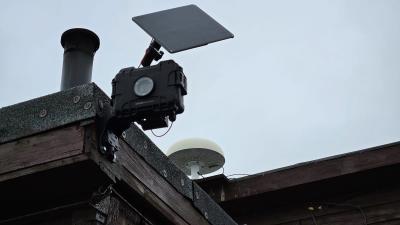
GNSS-IR Monitoring Station - NY-ALESUND Contact Full Name Dominik Próchniewicz email dominik.prochniewicz@pw.edu.pl Institution Warsaw University of Technology Info Observation Facility Landing Page https://crios.pl/ Observation Facility Type land platform (fixed) Observation Facility Status Pre-operational Core data No Part of SIOS Project CRIOS Observation Facility ID RiS ID(s) 12089 Geospatial location Coordinates POINT (11.89524 78.9177) Height above mean sea level (m) 42.00 Environment Site Information GNSS monitoring stations for estimation of snow depth value based on interferometric reflectometry method (GNSS-IR). GNSS receiver - geodetic class multi-frequency (L1/L2/L5) and multiconstellation (GPS/Galileo/BeiDou/GLONASS) receiver; GNSS antena - geodetic class precise multiconstellation antenna (Choke Ring type) installed on a metal mast (3 m hight). The installation is permanently attached to the ground and connected with the receiver with a 30 m cable. CRIOS – Cryosphere Integrated Observation Network on Svalbard Project financed from the EEA Financial Mechanism 2014-2021 operated by the National Science Centre in Poland Agreement no. UMO-2022/43/7/ST10/00001 to a predefined project no. 2022/43/7/ST10/00001 Project period: 08.09.2022 - 30.04.2024 (2029) Observed Variable(s) Observed Variable CRYOSPHERE>SNOW/ICE>SNOW DEPTH Start Date 2023-09-05T12:00:00Z End Date 2029-04-30T12:00:00Z Instrument model and serial number Trimble Alloy S.No. 6248R40105 Instrument routine maintenance N/A Sampling procedures Mutli-GNSS (GPS, Galileo, GLONASS, BeiDou) multi-frequency code and carrier-phase measurements are recorded in 10 seconds interval and transmitted via the Internet every 24 hours. Read more about GNSS-IR Monitoring Station - NY-ALESUND
GNSS-IR Monitoring Station - LONGYEARBYEN Contact Full Name Dominik Próchniewicz email dominik.prochniewicz@pw.edu.pl Institution Warsaw University of Technology Info Observation Facility Landing Page https://crios.pl/ Observation Facility Type land platform (fixed) Observation Facility Status Pre-operational Core data No Part of SIOS Project CRIOS Observation Facility ID RiS ID(s) 12089 Geospatial location Coordinates POINT (15.82982 78.20238) Height above mean sea level (m) 6.00 Environment Site Information GNSS monitoring stations for estimation of snow depth value based on interferometric reflectometry method (GNSS-IR). GNSS receiver - geodetic class multi-frequency (L1/L2/L5) and multiconstellation (GPS/Galileo/BeiDou/GLONASS) receiver; GNSS antena - geodetic class precise multiconstellation antenna (Choke Ring type) installed on a metal mast (3 m hight). The installation is permanently attached to the ground and connected with the receiver with a 30 m cable. CRIOS – Cryosphere Integrated Observation Network on Svalbard Project financed from the EEA Financial Mechanism 2014-2021 operated by the National Science Centre in Poland Agreement no. UMO-2022/43/7/ST10/00001 to a predefined project no. 2022/43/7/ST10/00001 Project period: 08.09.2022 - 30.04.2024 (2029) Observed Variable(s) Observed Variable CRYOSPHERE>SNOW/ICE>SNOW DEPTH Start Date 2023-09-01T12:00:00Z End Date 2029-04-30T12:00:00Z Instrument model and serial number Trimble Alloy S.No. 6302R40103 Instrument routine maintenance N/A Sampling procedures Mutli-GNSS (GPS, Galileo, GLONASS, BeiDou) multi-frequency code and carrier-phase measurements are recorded in 10 seconds interval and transmitted via the Internet every 24 hours. Read more about GNSS-IR Monitoring Station - LONGYEARBYEN
GNSS-IR Monitoring Station - HORSUND Contact Full Name Dominik Próchniewicz email dominik.prochniewicz@pw.edu.pl Institution Warsaw University of Technology Info Observation Facility Landing Page https://crios.pl/ Observatory Polish Polar Station Observation Facility Type land platform (fixed) Observation Facility Status Pre-operational Core data No Part of SIOS Project CRIOS Observation Facility ID RiS ID(s) 12089 Geospatial location Coordinates POINT (15.538176 77.001643) Height above mean sea level (m) 10.00 Environment Site Information GNSS monitoring stations for estimation of snow depth value based on interferometric reflectometry method (GNSS-IR). GNSS receiver - geodetic class multi-frequency (L1/L2/L5) and multiconstellation (GPS/Galileo/BeiDou/GLONASS) receiver; GNSS antena - geodetic class precise multiconstellation antenna (Choke Ring type) installed on a metal mast (3 m hight). The installation is permanently attached to the ground and connected with the receiver with a 30 m cable. CRIOS – Cryosphere Integrated Observation Network on Svalbard Project financed from the EEA Financial Mechanism 2014-2021 operated by the National Science Centre in Poland Agreement no. UMO-2022/43/7/ST10/00001 to a predefined project no. 2022/43/7/ST10/00001 Project period: 08.09.2022 - 30.04.2024 (2029) Observed Variable(s) Observed Variable CRYOSPHERE>SNOW/ICE>SNOW DEPTH Start Date 2023-08-29T12:00:00Z End Date 2029-04-30T12:00:00Z Instrument model and serial number Trimble Alloy S.No. 6251R40232 Instrument routine maintenance N/A Sampling procedures Mutli-GNSS (GPS, Galileo, GLONASS, BeiDou) multi-frequency code and carrier-phase measurements are recorded in 10 seconds interval and transmitted via the Internet every 24 hours. Read more about GNSS-IR Monitoring Station - HORSUND
Timelaps camera - KAFFIØYRA Contact Full Name Ireneusz Sobota email irso@umk.pl Institution Nicolaus Copernicus University in Toruń Info Observation Facility Landing Page https://crios.pl/ Observation Facility Type land platform (fixed) Observation Facility Status Operational Core data No Part of SIOS Project CRIOS Observation Facility ID RiS ID(s) 12089 Geospatial location Coordinates POINT (11.8264 78.6756) Height above mean sea level (m) 4.00 Environment Site Information The camera is installed at the main entrance to the NCU Polar Station. The lens is pointed in a westerly direction, towards Prins Karls Forland. CRIOS – Cryosphere Integrated Observation Network on Svalbard Project financed from the EEA Financial Mechanism 2014-2021 operated by the National Science Centre in Poland Agreement no. UMO-2022/43/7/ST10/00001 to a predefined project no. 2022/43/7/ST10/00001 Project period: 08.09.2022 - 30.04.2024 (2029) Observed Variable(s) Observed Variable CRYOSPHERE>SNOW/ICE>SNOW COVER Start Date 2023-10-01T12:00:00Z Instrument model and serial number https://seesense.eu/shop/camdo-time-lapse-solution-bundles/ - Sony DSC-RXO II camera system - SolarUp Bundle Comprising - CamDo 9 Watt Solar panel upgrade kit for Dry X enclosure - SanDisk Extreme Plus micro SD Card SDXC 128GB 170MB/s A time-lapse camera takes photos of the snow cover and ground cover in the area of the station in Kaffiøyra. Instrument routine maintenance Maintenance takes place at least once a year in spring (March/April) or summer (July/August). Sampling procedures Sampling every 6 hours and saving to internal SD card. Observed Variable LAND SURFACE>LANDSCAPE>LANDSCAPE PROCESSES Start Date 2023-10-01T12:00:00Z Instrument model and serial number https://seesense.eu/shop/camdo-time-lapse-solution-bundles/ - Sony DSC-RXO II camera system - SolarUp Bundle Comprising - CamDo 9 Watt Solar panel upgrade kit for Dry X enclosure - SanDisk Extreme Plus micro SD Card SDXC 128GB 170MB/s A time-lapse camera takes photos of the snow cover and ground cover in the area of the station in Kaffiøyra. Instrument routine maintenance Maintenance takes place at least once a year in spring (March/April) or summer (July/August). Sampling procedures Sampling every 6 hours and saving to internal SD card. Read more about Timelaps camera - KAFFIØYRA
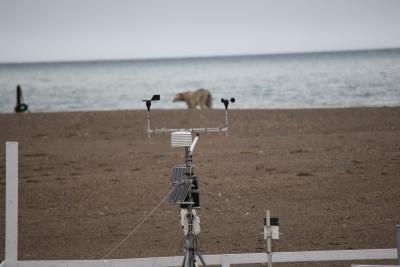
Automatic Weather Station - KAFFIØYRA Contact Full Name Ireneusz Sobota email irso@umk.pl Institution Nicolaus Copernicus University in Toruń Info Observation Facility Landing Page https://crios.pl/ Observation Facility Type land platform (fixed) Observation Facility Status Operational Core data Yes Part of SIOS Project CRIOS Observation Facility ID RiS ID(s) 12089 Geospatial location Coordinates POINT (11.8256 78.6752) Height above mean sea level (m) 2.50 Environment Site Information CRIOS – Cryosphere Integrated Observation Network on Svalbard Project financed from the EEA Financial Mechanism 2014-2021 operated by the National Science Centre in Poland Agreement no. UMO-2022/43/7/ST10/00001 to a predefined project no. 2022/43/7/ST10/00001 Project period: 08.09.2022 - 30.04.2024 (2029) Observed Variable(s) Observed Variable ATMOSPHERE>ATMOSPHERIC TEMPERATURE>SURFACE TEMPERATURE>AIR TEMPERATURE Start Date 2023-10-01T12:00:00Z Instrument model and serial number https://www.onsetcomp.com/products/sensors/ Instrument routine maintenance Maintenance takes place at least once a year in spring (March/April) or summer (July/August). Sampling procedures Sampling every 1 hour and saving to internal SD card. Data transmission via the Iridium system every 72 hours. Observed Variable ATMOSPHERE>ATMOSPHERIC WATER VAPOR>WATER VAPOR INDICATORS>HUMIDITY>RELATIVE HUMIDITY Start Date 2023-10-01T12:00:00Z Instrument model and serial number https://www.onsetcomp.com/products/sensors/ Instrument routine maintenance Maintenance takes place at least once a year in spring (March/April) or summer (July/August). Sampling procedures Sampling every 1 hour and saving to internal SD card. Data transmission via the Iridium system every 72 hours. Observed Variable ATMOSPHERE>ATMOSPHERIC WINDS>SURFACE WINDS>WIND SPEED Start Date 2023-10-01T12:00:00Z Instrument model and serial number https://www.onsetcomp.com/products/sensors/ Instrument routine maintenance Maintenance takes place at least once a year in spring (March/April) or summer (July/August). Sampling procedures Sampling every 1 hour and saving to internal SD card. Data transmission via the Iridium system every 72 hours. Observed Variable ATMOSPHERE>ATMOSPHERIC WINDS>SURFACE WINDS>WIND DIRECTION Start Date 2023-10-01T12:00:00Z Instrument model and serial number https://www.onsetcomp.com/products/sensors/ Instrument routine maintenance Maintenance takes place at least once a year in spring (March/April) or summer (July/August). Sampling procedures Sampling every 1 hour and saving to internal SD card. Data transmission via the Iridium system every 72 hours. Observed Variable ATMOSPHERE>ATMOSPHERIC RADIATION>INCOMING SOLAR RADIATION Start Date 2023-10-01T12:00:00Z Instrument model and serial number https://www.onsetcomp.com/products/sensors/ Instrument routine maintenance Maintenance takes place at least once a year in spring (March/April) or summer (July/August). Sampling procedures Sampling every 1 hour and saving to internal SD card. Data transmission via the Iridium system every 72 hours. Observed Variable ATMOSPHERE>PRECIPITATION>TOTAL SURFACE PRECIPITATION RATE Start Date 2023-10-01T12:00:00Z Instrument model and serial number https://www.onsetcomp.com/products/sensors/ Instrument routine maintenance Maintenance takes place at least once a year in spring (March/April) or summer (July/August). Sampling procedures Sampling every 1 hour and saving to internal SD card. Data transmission via the Iridium system every 72 hours. Read more about Automatic Weather Station - KAFFIØYRA
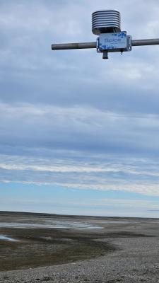
SPICE: Autonomous snow depth and glacier ablation station - NCU POLAR STATION Contact Full Name Ireneusz Sobota email irso@umk.pl Institution Nicolaus Copernicus University in Toruń Info Observation Facility Landing Page https://crios.pl/ Observation Facility Type land platform (fixed) Observation Facility Status Operational Core data Yes Part of SIOS Project CRIOS Observation Facility ID RiS ID(s) 12089 Geospatial location Coordinates POINT (11.8249 78.675) Height above mean sea level (m) 2.50 Environment Site Information Site Information https://a2photonicsensors.com/spice-snow-depth-real-time/ Spice - IoT telemetric sensor for snowpack depth measurement. The Spice sensor is a sonar-based sensor used for measuring the depth of the snowpack and monitoring its evolution during the winter season. The instrument performs temperature compensation so as to increase the accuracy of the measurement. CRIOS – Cryosphere Integrated Observation Network on Svalbard Project financed from the EEA Financial Mechanism 2014-2021 operated by the National Science Centre in Poland Agreement no. UMO-2022/43/7/ST10/00001 to a predefined project no. 2022/43/7/ST10/00001 Project period: 08.09.2022 - 30.04.2024 (2029) Second contact person: Michał Laska (michal.laska@us.edu.pl) Observed Variable(s) Observed Variable CRYOSPHERE>SNOW/ICE>SNOW DEPTH Start Date 2023-10-01T12:00:00Z Instrument model and serial number Spice Autonomous snow depth station for real-time measurement Manufacturer: A2 Photonic Sensors Instrument routine maintenance The sensor is serviced once a year in July-August when data is collected. Sampling procedures Sampling and recording every 1 hour and saving to internal SD card. The sensor is installed approx. 2 m above snow-free land surface. Observed Variable ATMOSPHERE>ATMOSPHERIC TEMPERATURE>SURFACE TEMPERATURE>AIR TEMPERATURE Start Date 2023-10-01T12:00:00Z Instrument model and serial number Spice Autonomous snow depth station for real-time measurement Manufacturer: A2 Photonic Sensors Instrument routine maintenance The sensor is serviced once a year in July-August when data is collected. Sampling procedures Sampling and recording every 1 hour and saving to internal SD card. The sensor is installed approx. 2 m above snow-free land surface. • Range: -40/+65 °C • Accuracy: ± 0.8 °C • Resolution: 0.1 °C Read more about SPICE: Autonomous snow depth and glacier ablation station - NCU POLAR STATION
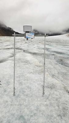
SPICE: Autonomous snow depth and glacier ablation station - WALDEMARBREEN T9 Contact Full Name Ireneusz Sobota email irso@umk.pl Institution Nicolaus Copernicus University in Toruń Info Observation Facility Landing Page https://crios.pl/ Observation Facility Type land platform (on ice) Observation Facility Status Operational Core data Yes Part of SIOS Project CRIOS Observation Facility ID RiS ID(s) 12089 Geospatial location Coordinates POINT (12.0399 78.6765) Height above mean sea level (m) 220.00 Environment Site Information Site Information https://a2photonicsensors.com/spice-snow-depth-real-time/ Spice - IoT telemetric sensor for snowpack depth measurement. The Spice sensor is a sonar-based sensor used for measuring the depth of the snowpack and monitoring its evolution during the winter season. The instrument performs temperature compensation so as to increase the accuracy of the measurement. CRIOS – Cryosphere Integrated Observation Network on Svalbard Project financed from the EEA Financial Mechanism 2014-2021 operated by the National Science Centre in Poland Agreement no. UMO-2022/43/7/ST10/00001 to a predefined project no. 2022/43/7/ST10/00001 Project period: 08.09.2022 - 30.04.2024 (2029) Second contact person: Michał Laska (michal.laska@us.edu.pl) Observed Variable(s) Observed Variable CRYOSPHERE>SNOW/ICE>SNOW DEPTH Start Date 2023-10-01T12:00:00Z Instrument model and serial number Spice Autonomous snow depth station for real-time measurement Manufacturer: A2 Photonic Sensors Instrument routine maintenance The sensor is serviced once a year in July-August when data is collected. Sampling procedures Sampling and recording every 1 hour and saving to internal SD card. The sensor is installed approx. 2 m above snow-free glacier surface. Observed Variable ATMOSPHERE>ATMOSPHERIC TEMPERATURE>SURFACE TEMPERATURE>AIR TEMPERATURE Start Date 2023-10-01T12:00:00Z Instrument model and serial number Spice Autonomous snow depth station for real-time measurement Manufacturer: A2 Photonic Sensors Instrument routine maintenance The sensor is serviced once a year in July-August when data is collected. Sampling procedures Sampling and recording every 1 hour and saving to internal SD card. The sensor is installed approx. 2 m above snow-free glacier surface. • Range: -40/+65 °C • Accuracy: ± 0.8 °C • Resolution: 0.1 °C Read more about SPICE: Autonomous snow depth and glacier ablation station - WALDEMARBREEN T9